For an in-depth listing of the many services available within our community, please browse through our A-Z Guide.
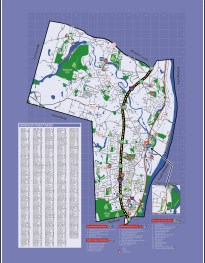
This map of Windsor contains great information on a variety of locations from Government facilities and schools to points of public interest. It also contains a street index to help locate specific streets and locations nearby. Alternatively, if you are looking for driving directions try using Google Maps.
Located six miles north of Hartford, Windsor covers a 31.1 square mile area on the west bank of the Connecticut River, located an equal distance from New York City and Boston. The Town is only minutes from Bradley International Airport and is also well served by a main-line railway between Boston and New York. Interstate 91, a major expressway to New York and northern New England, traverses the Town and has seven interchanges within the Town’s borders. The Connecticut Turnpike, the Massachusetts Turnpike and the New York Thruway are also easily accessible.
… By Train …
Amtrak commuter trains stop in historic Windsor Center several times each day, running from Springfield to New haven with connections to Boston and New York. Contact Amtrak for the latest train schedule for windsor.
… By Air …
Windsor has the advantage of being located just ten minutes away from Bradley international Airport. Contact Bradley international for the latest flight schedules to Connecticut.
… and, By Bus
Connecticut Transit Company busses serve the needs of commuters throughout greater Hartford with several routes through Windsor. Contact Connecticut Transit, at 860.525-9181 for the latest bus schedules for Windsor.